With thanks to Cllr Philip Ellwood, Slow Ways volunteer, for information provided)
Rogiet Community Council have given their support to the Slow Ways initiative as part of our drive to tackle climate change.
The Slow Ways is a unique project which hit the ground running during the Spring 2020 lockdown with the help of 700 volunteers. The aim of the project was to provide the most comprehensive walking network ever recorded, covering the whole of Great Britain. With the nation focused on their permissible 'daily exercise' volunteers were keen to help draft local walking routes, and to help plot further afield routes via Ordinance Survey maps. The result is a network that links the cities and town of Great Britain, as well as thousands of villages, by walking routes alone - providing opportunities for people to make a conscious choice between transport or walking for a multitude of activities such as getting to work, shopping, visiting friends (in non-Covid times obviously!)etc.
As far as possible routes are direct, off-road, safe, accessible, easily navigable and pass through settlements with services and public transport hubs. The Slow Ways network – through its unique approach to plotting, mapping and recording routes – aims to make it easier for people to see, plan, enjoy and share walks between places.
The average Slow Way route in England and Wales is 12km while in Scotland it is closer to 20km. Hundreds of routes in urban areas are under 5km.
You can find more information and videos on Slow Ways via the following Tweets from BBC News and ITV News
Slow Ways in Rogiet and surrounding areas
Initially
there will be five Slow Ways in our local area:
- Newport to Caldicot, 14 miles / 23 km (see details below)
- Caerleon to Caldicot, 11 miles / 18 km
- Usk to Caldicot, 15 miles / 24 km
- Caldicot to Chepstow, 7 miles / 12 km
- Usk to Chepstow, 14 miles / 23 km
Slow Way for Newport to Caldicot (through Rogiet village)
This route will enter Rogiet boundary from Undy, via ‘The Moors’ road, then over the M4 motorway and railway bridges, passing Severn Tunnel Junction entrance road in the process. It will then head up the footpath past the allotments and onto Westway, after passing through the new heart of our village, in the form of the new Community Café / Shop.
From Westway, the route will go along Grenville Terrace and then through the footpath to Chestnut Drive, from where it will head north to the B4525 via the avenue of old horse chestnut trees (the old approach to Ifton Manor Farm). It will then head eastwards along the B4245 (paved along here) to leave Rogiet boundary near to Cherry Tree home.
The screenshots below describe the route in levels of detail.
Newport to Caldicot whole route:
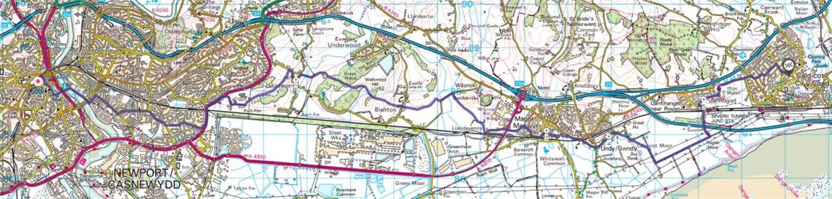
Section through Rogiet community boundaries:
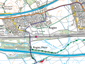
Rogiet village centre detail:

Note: the number ‘5’ shown on the route will be a route waypoint, named ‘Rogiet’.
Here is the full list of waypoints for the route:
- Newport (rail station)
- Llanwern (Milton Hotel)
- Magor (square)
- Undy (church)
- Rogiet (community café / shop)
- Caldicot (cross monument)
If you would like to help review a route or two, please sign up on the holding website here: Slow Ways - a network of walking routes connecting Great Britain
For more information, have a look at the Slow Ways FAQ page here: Frequently Asked Questions - Slow Ways